
Streamside Brochure
.4 MB PDF |
- Stream Protection
- Streambank Maintenance
- Streamside Stormwater Management
- Streamside Lawn and Garden Care
- Streamside Plantings
|
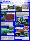
Streamside Poster
2.8 MB PDF |
- Preventing Streambank Erosion
- Plants for Streambank Protection
- Plants for Streamside Wildlife Habitat
|
Scajaquada Creek
Watershed
Management Plan
11 MB PDF |
The Scajaquada Creek Watershed Management Plan presents recommendations, objectives and action items for restoring and protecting natural resources of the Scajaquada Creek Watershed. The plan is a community-based effort to provide local municipalities, community groups and organizations with resources to complement their watershed planning and protection activities.
|
Water Quality Analysis
Eighteenmile Creek
2.8 MB PDF |
Eighteenmile Creek, Erie County, New York, flows from south to north then turns west to empty into Lake Erie (Figure 2.1). The watershed of Eighteenmile Creek includes parts of several communities including Eden, Evans, Hamburg, and Boston. The purpose of this research project is to: 1. Compare historical data to data from field samples collected in 2000 to
determine if a change has occurred in the waterway and 2. Compare data from all sampling years to present day water quality sampling standards. Previous studies conducted by the Erie County Department of Health (ECDH) in 1970 and 1973 included testing for total coliforms, fecal coliforms, biological oxygen demand (BOD), orthophosphates, chlorides and nitrates. Therefore, the 2000 sample data collection concentrated on the above parameters to evaluate
current water quality. The results of this study will help to describe or characterize the present state of the water quality at Eighteenmile Creek and provide information to the surrounding communities of Eden, Evans, Hamburg and Boston.
|
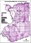
Draft Environmetal
Sensitivity Index Map
6.8 MB PDF |
Geographic features have been assigned a value of 10 points. There are 10 features considered and they are as follows: NYS DEC Wetlands, USFWS NWI Wetlands, 100 Foot Stream Buffers, 100 Year Floodplains, Agricultural Districts, Sensitive Archeological Areas, Hydric Soils, Prime Farmland Soils, Steep Slopes - 15% Minimum Grade, NYSDEC Natural Heritage Program Data.
100 points would be the Maximum Value for any area. |
NRCS
Residential Stormwater
Management Areas
>.2 MB PDF |
Residential Stormwater Management Areas |

WNY Stormwater
Coalition Brochure
>.2 MB PDF |
Automotive & Related Industries |

WNY Stormwater
Coalition Brochure
>.2 MB PDF |
Concrete & Mortar Operations |

WNY Stormwater
Coalition Brochure
>.2 MB PDF |
Construction Site Stormwater Runoff Control |
WNY Stormwater
Coalition Brochure
>.2 MB PDF |
Household Guide to Preventing Stormwater Pollution |

WNY Stormwater
Coalition Brochure
>.2 MB PDF |
Pesticide Application, Lawn Care and Landscaping |

WNY Stormwater
Coalition Brochure
>.2 MB PDF |
Hospitals, Medical Treatment Centers & Healthcare Facilities |

WNY Stormwater
Coalition Brochure
>.2 MB PDF |
Mobile Cleaners: Carpet, Upholstery Cleaners, Janitorial Service Providers |

WNY Stormwater
Coalition Brochure
>.2 MB PDF |
Roadwork and Paving |

WNY Stormwater
Coalition Brochure
>.2 MB PDF |
Pools, Fountains and Spas |

WNY Stormwater
Coalition Brochure
>.2 MB PDF |
Food & Restaurant Industries |


